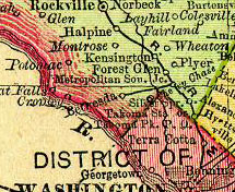
This has been a very busy year so far, with all sorts of new Georgetown Branch info popping out of the woodwork and the internet! A post on the always interesting Abandoned Rails group on Facebook yielded this fascinating collection of scans from the 1895 ed. of the Rand McNally Railroad Atlas.
 If you zoom in on the area of the Georgetown Branch you will note not only the arrow-straight line running to Bethesda (strange that it’s straight, and that it goes to Bethesda) but also that the junction is named “Metropolitan Sou. Jc.” and not “Georgetown Junction.” This should be quite obvious, in fact, since the line at this time was named the Metropolitan Southern RR. (to build from the junction with the Metropolitan Branch down to the Palisades), the Georgetown Barge, Dock, Elevator & Ry. Co. (from Georgetown up to the Palisades) and the Metropolitan Western RR (the line to extend into VA which was never realized). Nonetheless, it’s an interesting verification to the history that prior to the line actually being extended to Georgetown and the branch line taking on its namesake, this junction was known by a different name.
If we all remember our Georgetown Branch history, the line from Georgetown Junc… er, Metropolitan Southern Jct. on to Chevy Chase, MD was constructed some time around 1894 to provide coal for the power plant built for the Chevy Chase Lake and Kensington Ry. trolley line. The line was also part of the vision the B&O had to provide a link to the South by extending across the Potomac River near the Dalecarlia Reservoir, which ultimately never happened. So at the point this map had been created we know the line existed to Chevy Chase Lake. Whether it actually extended to Bethesda, I’m not sure, but it would be very interesting to know!