Trump’s list of infrastructure priority projects. Note #23.
Monthly Archives: January 2017
Mystery: Old Stones at Connecticut Ave
Ostensibly, in my lifetime, the Purple Line of the Washington Metro system will be built, connecting Silver Spring and Bethesda, MD. Laying atop the Georgetown Branch right-of-way from Bethesda to the Metropolitan Branch, the construction effort to create this modern rapid transit line will all but eradicate any remaining surface remnants of the beloved B&O branch I have been researching for so many years. Bridges, rail fragments, grading, ties, leftover sign posts and hints at where the tracks led will be eliminated by heavy earth moving equipment. Over the years I’ve attempted to capture pieces of this history by visiting various sites and photographing what’s remaining which leads me to the purpose of this post.
A post on the Atlas Obscura website which covers some stones hidden away in Rock Creek Park, long-forgotten, dumped there after a renovation project on the US Capitol, got me thinking. It reminded me of something similar I had seen while on my last GB tour. On my last visit to the B&O’s crossing at Connecticut Ave., I noticed a curiosity hidden away in the overgrowth near the end of the team track, (much of which is still extant!) a large pile of cut, shaped stones.
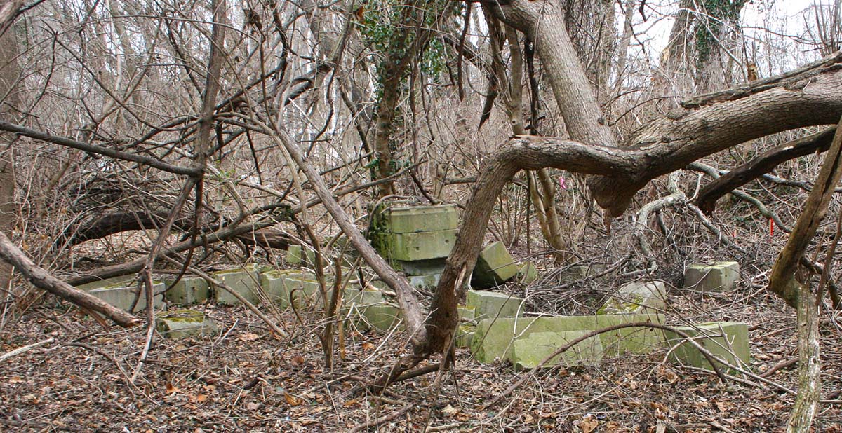
I am not an expert when it comes to building stones, but these really caught my eye. The pile is located just off of the Crescent Trail path and is hidden in some thick brush. They vary in size and shape, some being long, others much stouter. There are carvings on some of them. I regret not going in for a closer look but at the time I didn’t think to do so. If you’d like to see my photos from that trip, you can see them here.
And here is where the mystery begins. It has long been legend that much of the stone used in construction on the National Cathedral was delivered here by rail and then trucked up Conn. Av to the Cathedral, which is located at the intersection of Mass. Av. & Wisconsin Av. Construction on the Cathedral began in 1907 and continued steadily until the early 1990s. I would imagine that in the early days of construction the thought of stone being delivered for the massive project probably was brought via rail and it makes sense that it was delivered here at Connecticut Av. and trucked to the building site. There aren’t many other feasible options considering that long-distance trucking was a long ways away. So the possibility is there.
Where did these stones come from? Is there a way of figuring that out? Will there be quarry marks on them? When I first saw these stones, I thought that perhaps they were the remnants of the gantry crane that was once located here on the team track at Connecticut Av.
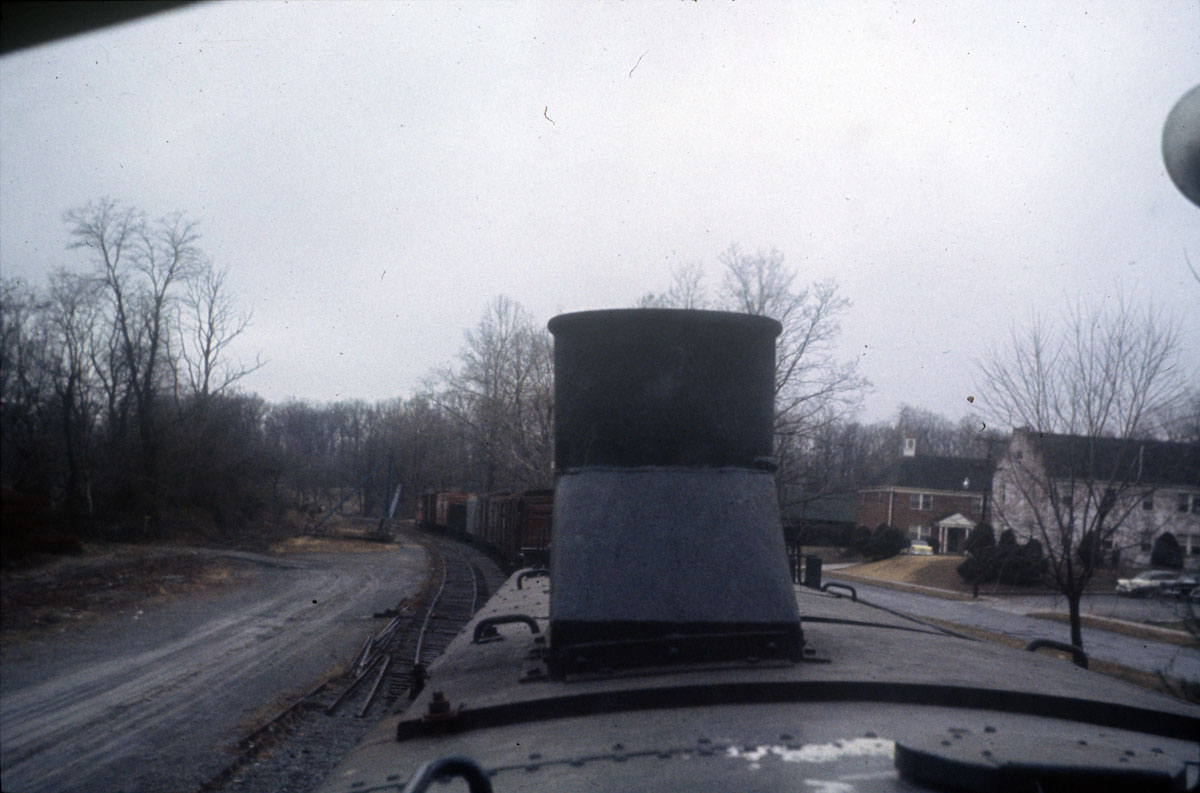
If you look carefully, to the left of the tail of the train is the old gantry crane. This crane shows up in photos that I have seen from the 1920s, 30s and on into the late 50s and early 60s, possibly. The pile of stones is located near to where the crane once stood. Interestingly, the “team track” is actually to the *left* of the gantry crane in this photo, behind it. Unless the entire mechanism can rotate 180 degrees that rear track would not be serviceable by the crane. It’s a bit clearer in this photo:
One can see the crane, with its tailing arm coming off the top, with the swing arm retracted to the side to allow trains to pass by. The team track is much more clearly visible to the far left. There is a suspicious pile near the team track in this photo, but you’ll notice that in the newer photo above, it’s gone. I believe the location of the stone that I found in the woods is further back, behind the crane, just out of view of these vintage photos.
So, further research is necessary to figure out this mystery. Perhaps the folks at the Cathedral could identify the stones. Or, perhaps there’s someone with a story behind how they got there. Maybe they’re just landscaping stones for a fancy building/home that a builder dumped there illegally. Or, just maybe, they were surplus stones intended to be delivered to the Cathedral site, long-forgotten and hidden from memory. All I know is that in a short amount of time; months, maybe years if we’re lucky, these will be gone. Picked up, dropped in a dump truck, and hauled away for fill, to be buried somewhere forever. I hope someone can shed some light on it before then!
A Most Interesting Tidbit – Valuation Map Surprise
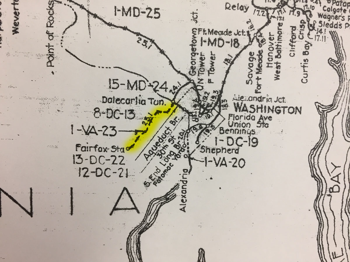
While visiting the B&ORRHS Archives building in Eldersburg, MD today I noticed an interesting depiction on the large Valuation Map “key” hanging on the wall in the collections room. This is a comprehensive view of the entire B&O RR system, with indications for major sections, distances and locations. On the map, the Georgetown Branch is indicated. However, there is a junction point at “Dalecarlia Tun.” where the Branch continues on down along the Potomac River into Georgetown. However, at the junction, there is also a dashed line that proceeds across the Potomac River and on into Virginia, terminating at “Fairfax Sta.” I have highlighted it in yellow on the photo I snapped with my phone, below.
I have researched this proposed line before, in fact I purchased a map off of eBay that showed the same proposed line and shared it on this blog. The curious thing to me is that the proposed line, which was one of the early visions/purposes for the “Georgetown Branch” was never actually built. But, it is indicated on this map, which means there are likely official Valuation maps associated with this right of way. Looking at the map, I see 8-DC-13, 1-VA-23, 13-DC-22 and 12-DC-21. I believe those are all references to maps and will have to check with the Archives to see what they have on hand. Onward…