I was tipped off by good friend and Archivist Nick F. to the large collection of aerial photos at the National Archives shot during the early-mid 1900s. The most challenging part of my research has always been this period. The line was finished in 1910 and at that point and up into the late 1940s personal cameras were not really a thing. Folks weren’t out there snapping photos of common things unless they had a reason. Photos were more intentional and administrative or commercial in purpose. The B&O had a collection of valuation maps and photos shot around WWI. Over time, when a project was enacted, they would take additional photos. Of course there were roster shots and things of that nature, and it was very much documentation. So, when I saw these images, which largely span from the 19-teens up to the 1940s, I was floored. They are a window into a world that I have yearned to see. It will take me a good amount of time to get through all of the images but I plan on sharing them here when I can. Enjoy!
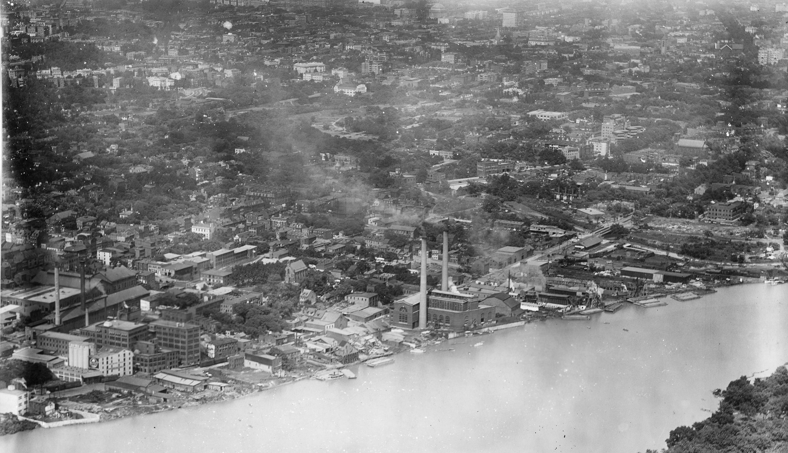
This first image is particularly interesting for a few very special reasons. Let’s start with one that I have been waiting for some time to see with clarity: the extension of the Branch that crossed Rock Creek and skirted along the Potomac to the construction site for the Lincoln Memorial. This siding made an appearance on the B&O Form 6 which listed all sidings along the line, but photos have been elusive. You can also clearly see the peculiar curved loading dock on the right side of the old B&O freight house located at the end of the line.
I also noticed that the Wilkins-Rogers Milling building looks very different and that is because this is the “old” mill that stood on the site until it burned down in a fire on July 4, 1922; a year or so after this photo was taken. There is a massive logo painted on the side of the mill which I believe is related to cotton production, which the mill apparently handled prior to being rebuilt.
There are SO many other details to soak up like the track arrangements, the old Capital Traction power plant (perhaps loading coal from barges or undergoing some construction?), The “new yard” wouldn’t be built for another 20 years or so. This was a busy time in Georgetown.
Ben, great score with this photo. A lot to take in here, including the Godey Lime Kilns – each with smoke stacks in place – on the eastern bank of Rock Creek. We also get a fair view of the team tracks where coal and aggregates were transshipped from rail to barge. Georgetwonwas busy, but probably foul-smelling place in those days.
wow
A lot hadn’t been built yet. You can see that the industrial center of gravity was up toward the canal.
I spy with switching moving an oil tank car in the yard.
I would have expected to see hopper cars at the Capital Traction power plant. Instead I think I see a bucket crane.
Next to Wilkins-Rogers is the paper mill. Looks like it was busy loading cars in the street.
Christopher – yes! Regarding the power house – agreed. I have puzzled over this. There are a few more photos in the archives that show the area a bit better. Let me see if I can find one. I know that when the power house was built they laid a spur that curved off of the B&O tracks, swung around behind the power house and then switched back along the curved wall into the plant for unloading. What I suspect is that they would also take coal from barges and thus there was the crane unloading that barge. Maybe they had a cable & pulley system to shuttle a hopper back and forth from the crane into the plant for unloading. Perhaps initially the spur from the B&O was just to facilitate heavy machinery being brought into the plant. Until more info surfaces, it’s all conjecture! I have never seen a photo showing a freight car on that spur. Keep looking… 🙂
Do you know when the Paper Mill went out of business? I’d like to include some related traffic on my layout, but I have yet to figure out the details of that business.
OK, welp, I just ate my own words! LOL – I just found a photo that shows a few cars on the loading track! I am going to post it now… stand by! 🙂
Old City Directories would tell you when the paper mill was operating. It is another mystery to me: no siding and no obvious supply of wood chips or pulpwood. I remembering going through the city directories, but I do not have easy access to my research at this moment (that was 35 years ago!).