YouTuber Nathan Carrick has posted a brief video showing some of the latest construction progress on the Georgetown Branch at the Connecticut Ave. crossing as well as at Wisconsin Ave in Bethesda. I have wanted to visit the construction site for weeks and am thankful he posted some footage. I was most curious about the old team tracks hidden in the woods at Conn. Ave (in the video, they are behind the excavator) and it appears they are still there, as the area is marked with red tape to preserve the forest. (thankfully) Don’t know how long that will last, but it’s nice to see for now.
Seeing the Branch torn up is painful as they are erasing many vestiges of the original right-of-way that will never be replaced. At the same time, it’s somewhat thrilling to me to think about riding a train on the old RoW once again.
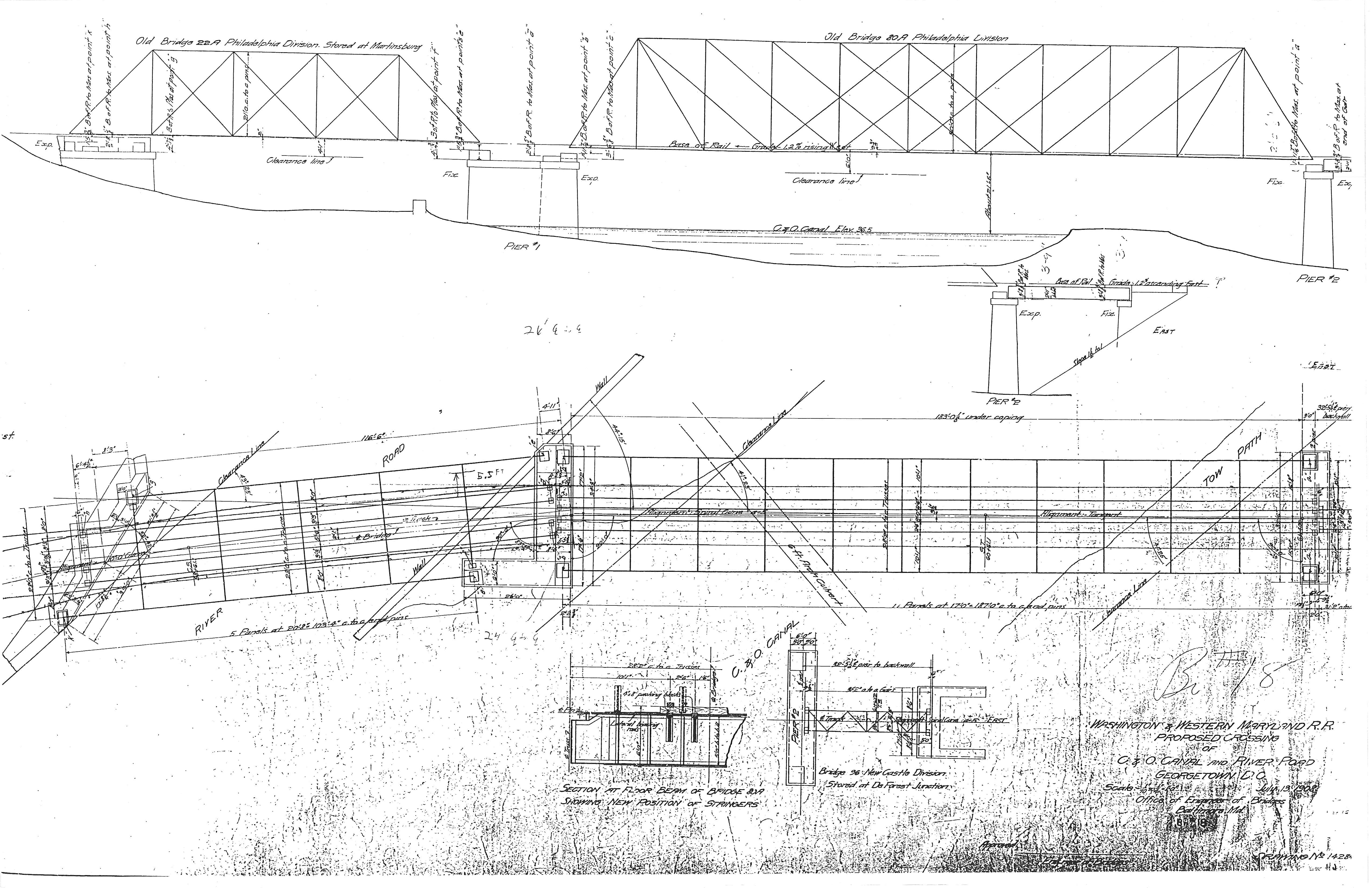
I found this link ages ago but wanted to list it here in case anyone is curious. This gentleman, Craig Bisgeier, has a New England model RR set in 1892. On his layout he needed a Whipple Truss bridge so he set out to kitbash/scratchbuild one from two Central Valley 150′ Pratt Through Truss bridge kits. The build is pretty involved and detailed. I wish there were more photos but nonetheless it’s a great resource for a modeler like me who is considering this daunting task! One benefit I do have is a full set of blueprints of the bridges crossing the canal. My plan is to laser-cut custom pieces as needed from thin mat board. More on this in the future.
While doing a bit of research on lumber companies in Bethesda, I came across the “who we are” page for ProMark Real Estate, whos predecessors included Einsinger Mill & Lumber Co, which occupied the space at Woodmont Ave & Bethesda Ave. This is the “lumber mill siding” we see so often in photos of the Bethesda yard. This is also the siding that was uncovered a few years back during excavation for the new apartment building. The family has a rich history of building in Montgomery County and the pages are worth a read! They were customers of the Georgetown Branch since the 1920s to the end. Really neat!
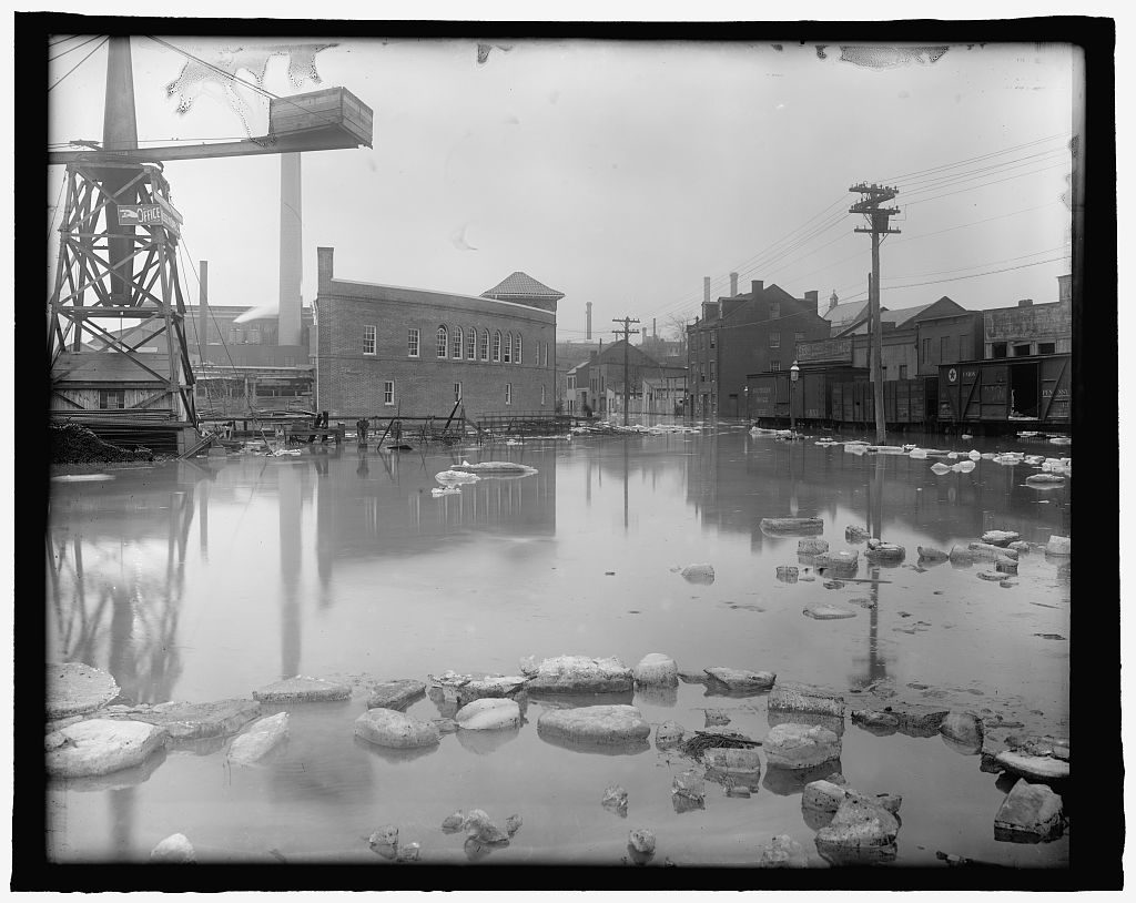
Flood, Wash., D.C., Feb. 1918. Washington D.C, 1918. Feb. [Photograph] Retrieved from the Library of Congress, https://www.loc.gov/item/npc2008011357/.An ice dam in the winter of 1918 resulted in massive flooding and damage along the waterfront in Georgetown. This photo is a neat perspective that I have never seen before. The location is the far East end of the Georgetown Branch, basically at the end. Just to the the right, the three freight cars sit on Water St. (aptly named in this situation). Just to the right of the photographer is the old B&O freight station. In front there is a large curved building which sat in front of the Smoot Sand & Gravel plant. Not sure if that’s what it was at this point. I have to check the maps. And just behind it you can see the tall light-colored stack of the Capital Traction Power House, which was constructed 8 years prior in 1910. Views of the waterfront in the early years of the Branch are few and far between so I treasure each one! Hope you enjoy this one as much as I did.
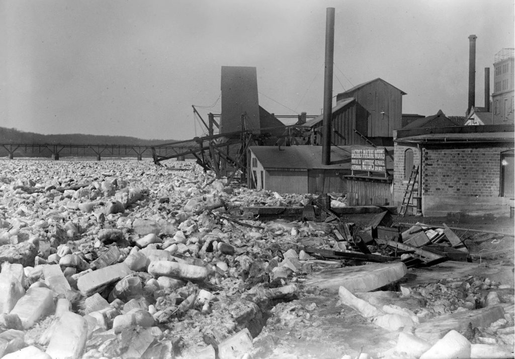
Harris & Ewing, photographer. POTOMAC RIVER ICE JAMS. Washington D.C, 1918. Photograph. Retrieved from the Library of Congress, https://www.loc.gov/item/hec2008007434/.
The Capital Weather Gang with the Washington Post, a favorite of mine, posted a neat article discussing the history of ice damming and ice floes in DC, specifically in the Georgetown area, as that is the area most susceptible due to the location of the old Aqueduct Bridge. Ice damming occurs when there is a long cold spell and large rivers freeze with a subsequent fast warming period. This causes the ice to quickly break up and flow down stream. If there is a bottleneck or obstruction , the ice will pile up and dam. Once those dams break, they unleash a torrent of fast-moving water laden with ice & debris which causes destruction down stream.
DC has had its fair share of ice dams and ice floes over the years, some worse than others. The 1918 incident was probably the worst in terms of destruction. Have a look for yourself. The WaPo article includes many great photos. Incidentally, here is a Google Maps view of the photo above!
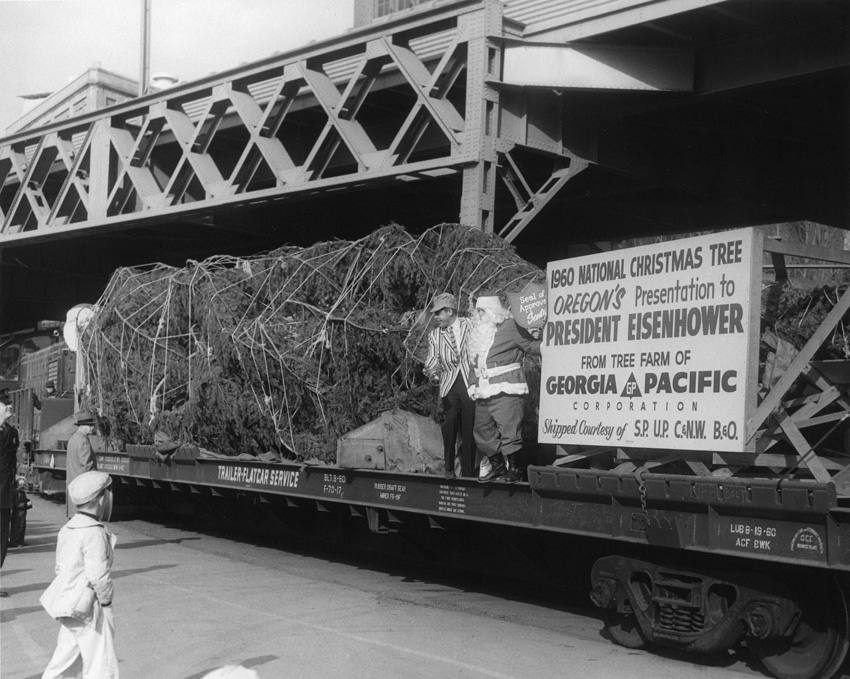
I found this neat photo on the Forest History Society website while searching for more info on the National Christmas Tree. The 1960 National Christmas Tree from Oregon is received in Georgetown by an enthusiastic Santa and … railroad employee? That striped jacket is something else. A policeman and excited little boy look on. Note the diesel engine at the end of the car. The shield-shaped sign the man is holding reads “Seal of Approval, Santa”
Georgetown Branch, Washington, DC, 1960 – National Christmas Tree is delivered. Photo from Forest History Society.
Recently the DC Dep’t of Transportation published thousands of images on a new photo archives page. It’s a wonderful peek back into transportation history in the District and includes many, many wonderful photos featuring the Georgetown Branch, specifically in the area around Georgetown. Photos date from the 30s and 40s all the way to the 80s and beyond in some instances. There are too many to share here, but with a little time and patience you can browse through the tagged images and enjoy these steps back in time. Have fun!
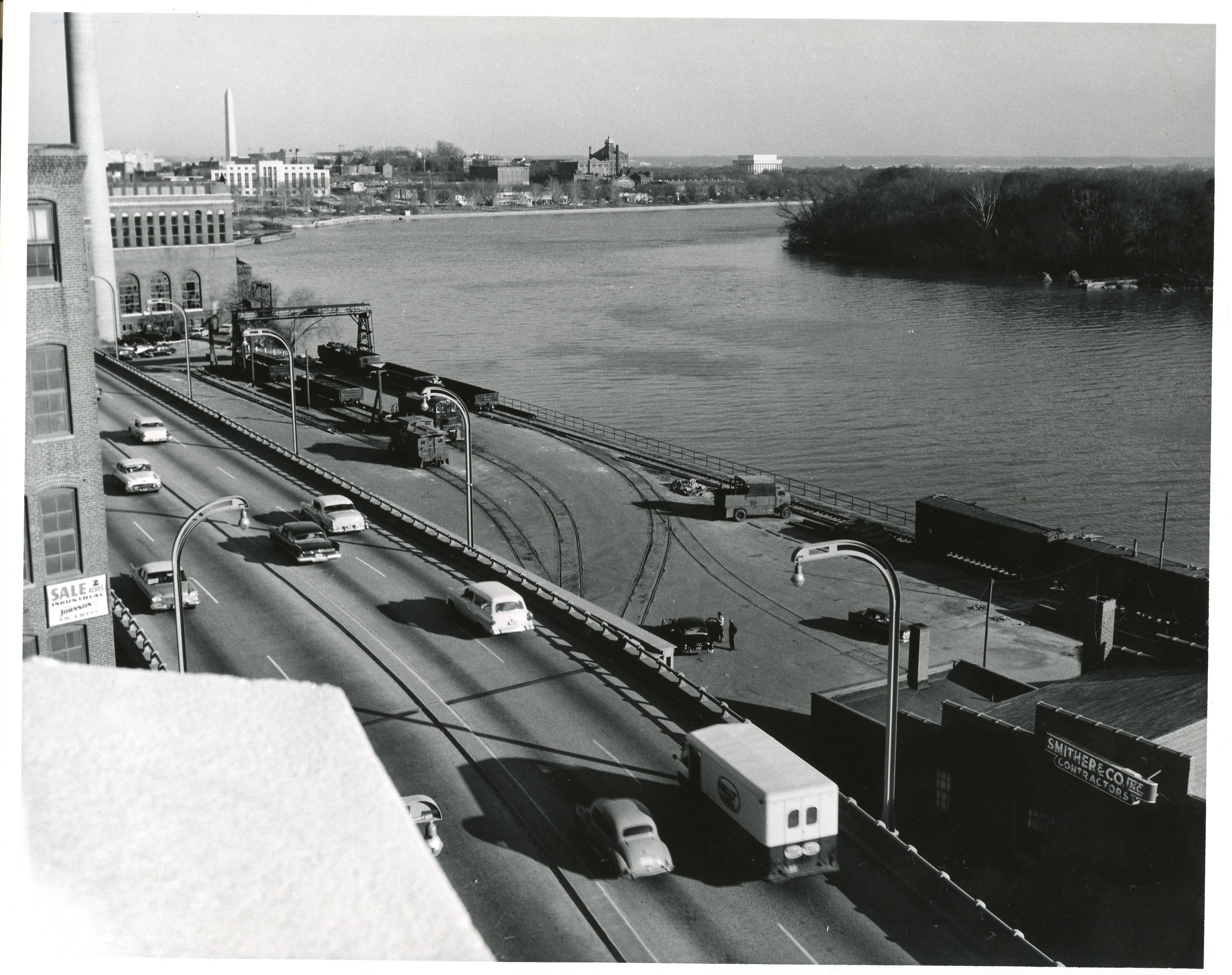
This view of the Whitehurst Freeway and B&O yard shows a yard bustling with activity down on the waterfront. The photo was taken some time in the 50s or 60s, by my guess. Photo credit: District Department of Transportation (DDOT)
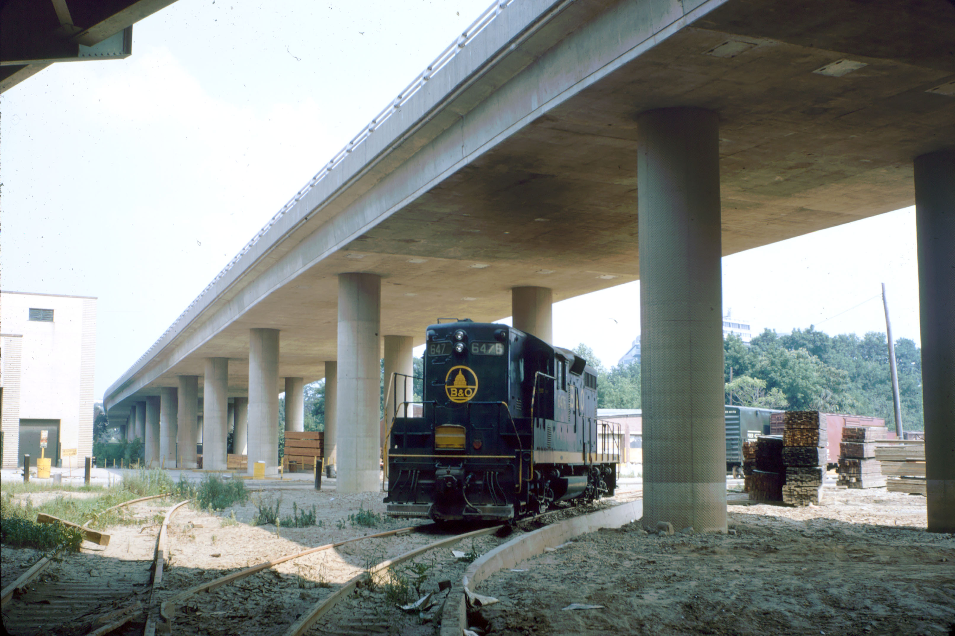
July 23, 1972 B&O 6476, Stranded in Georgetown after Hurricane Agnes damaged the Branch.
I purchased this original slide off of eBay a few weeks ago. Here’s the story behind the image. On June 19-22, 1972 Hurricane Agnes made its way across the Southeast USA and on up the coast to the Mid Atlantic, wreaking havoc along its way. DC saw its share of major flooding, with the Georgetown Waterfront being particularly badly hit. At the time, traffic on the Georgetown Branch had dwindled to a train every few days or once a week, depending on conditions. The rumor was that the B&O was looking for a way to get rid of it and had it not been for this locomotive, the branch may have been abandoned right then and there. Why, you say?
About five years prior, arsonists had set fire to the beautiful long wooden trestle crossing the creek. The spectacular blaze damaged the trestle, but they were able to salvage it.
1967 – Arsonists set fire to the Rock Creek trestle. G. Fred Stork photo, collection of the late Wm. Duvall.
When Agnes came through, it wrought havoc with incredibly heavy rains and destructive winds. The Georgetown Branch did not just suffer in Georgetown along the waterfront, but probably most significantly in its crossing of Rock Creek. The already-weakened trestle was devastated by flooding at Rock Creek and collapsed into the creek below.
The B&O had to figure out what to do: rebuild, or just call it a loss and seek abandonment. But there was one big problem. Engine 6476, now isolated in Georgetown along the waterfront. The engine was too valuable to scrap and too heavy to haul out, so the railroad opted to rebuild. This time, the bridge was repaired with steel. New bents were laid in and the whole structure was shored up.
1972 the B&O trestle across Rock Creek is rebuilt following destruction from Hurricane Agnes. Note the charring from the arsonists damage five years prior.
The branch is still in use today, as part of the Crescent Trail, having been cleaned up a bit and had a second deck laid on top of the rails so cyclists and pedestrians can enjoy the beautiful views of the creek valley. (Yep, the rails are still there! Next time you’re there, peek under the walkway and you’ll see the original rails and wood decking) So next time you are in Georgetown or strolling across the Rock Creek trestle, remember the story of the loco that saved the railroad. The Georgetown Branch would live on in service for another 13 years, until 1985.
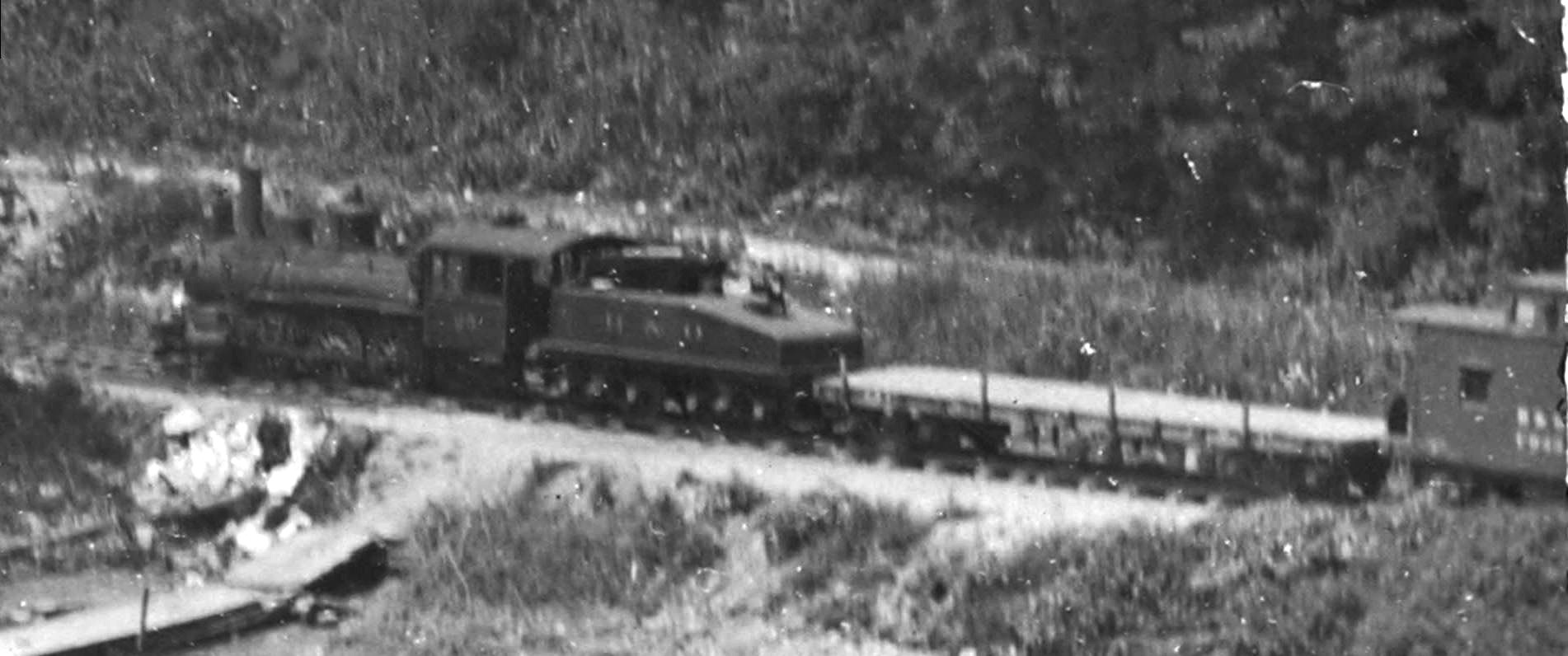
B&O #25 0-6-0 D2 engine with work train parked in Georgetown, ca 1910
I found this photo on the DCDIG website a few weeks back. It’s a very nice photo of the waterfront, showing a few of the boathouses which line the shore West of the aqueduct bridge, which this photo was taken from. Of particular interest is the B&O engine (#25 I believe), flat car and caboose parked on the Georgetown Branch main. How cool is that? It gets even cooler.
Closeup, B&O #25 0-6-0 D2 engine with work train parked in Georgetown, ca 1910
I believe this engine, car and caboose is the work train that was sent down the newly-opened Branch to complete a very special project; the widening of the Aqueduct Bridge arch, to allow trains to pass beneath. In a couple photos shared to Facebook a year or so ago a Mr. Ulles posted a couple photos of his ancestor who was part of the team who completed the work on the arch. The photos are really windows into the past that I never thought I’d see. Based on the number on the engine (which I believe is #25), the configuration of the engine (0-6-0, class D2), the train consist (flat car + caboose) and the general surroundings, I do believe this is the work train. This would put the photo at some point in the spring/summer of 1910 and paints more of the picture of what Georgetown looked like when the B&O finally arrived.