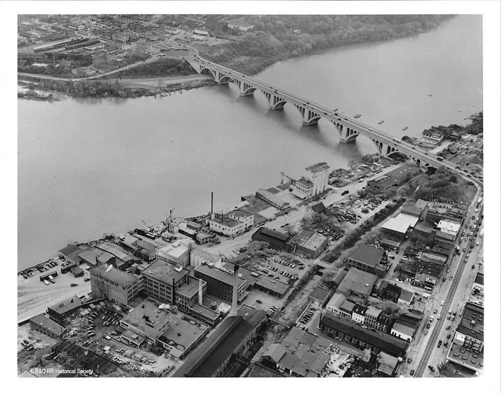
I scanned these eleven images, which are 11″x14″ B&W photos, which were originally part of the H. Smith collection. They now reside in the B&O RR Historical Society Archives in Eldersburg, MD. These photos are housed in an old photo album and are completely unmarked. I’m not sure of their original purpose but I suspect it has something to do with development along the Waterfront including the Whitehurst Freeway. If you are interested in the industrial area of Georgetown, these are a treasure trove of information. For me, they answer many questions about track alignment, industries and the state of the city during the time frame I am modeling. Jackpot! Enjoy!
This is very much a work in progress. It’s not complete, and I’m aware of the shifting nature of various structures, track placement and equipment placement that changed over the many years the Branch was in service. There are many labels that are incorrect or missing. It’s meant to be a nice reference point, so that if you are curious just where the track crossed the streets of Bethesda, or maybe where that yard was in Georgetown, you can have a look and see. I’ve used multiple sources for this project including B&O Valuation maps, photographs, historic aerial imagery and maps. I hope to update it more (photographs would be nice!) when I have the opportunity. Enjoy!
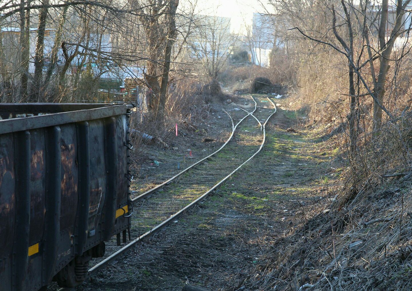
A recent brush clearing effort has revealed some of the original Georgetown Branch trackage and switch leading up to the E.C. Keys / recycling plant siding at Georgetown Jct. According to folks on the CSX “Cap, Met, and OML” subs, Railfans Facebook Group the clearing is being done for MoW equipment which will be utilizing the trackage. It’s neat to see tracks reappear after so long! Here is a photo taken by Janusz Mrozek showing the recent clearing. Thanks, Janusz!
Ostensibly, in my lifetime, the Purple Line of the Washington Metro system will be built, connecting Silver Spring and Bethesda, MD. Laying atop the Georgetown Branch right-of-way from Bethesda to the Metropolitan Branch, the construction effort to create this modern rapid transit line will all but eradicate any remaining surface remnants of the beloved B&O branch I have been researching for so many years. Bridges, rail fragments, grading, ties, leftover sign posts and hints at where the tracks led will be eliminated by heavy earth moving equipment. Over the years I’ve attempted to capture pieces of this history by visiting various sites and photographing what’s remaining which leads me to the purpose of this post.
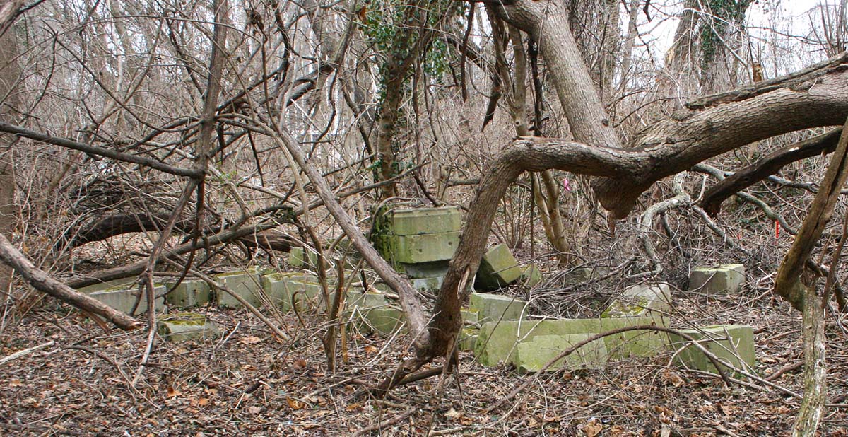
A post on the Atlas Obscura website which covers some stones hidden away in Rock Creek Park, long-forgotten, dumped there after a renovation project on the US Capitol, got me thinking. It reminded me of something similar I had seen while on my last GB tour. On my last visit to the B&O’s crossing at Connecticut Ave., I noticed a curiosity hidden away in the overgrowth near the end of the team track, (much of which is still extant!) a large pile of cut, shaped stones.
2015 Pile of stones located at Connecticut Ave crossing. Ben Sullivan photo.
I am not an expert when it comes to building stones, but these really caught my eye. The pile is located just off of the Crescent Trail path and is hidden in some thick brush. They vary in size and shape, some being long, others much stouter. There are carvings on some of them. I regret not going in for a closer look but at the time I didn’t think to do so. If you’d like to see my photos from that trip, you can see them here.
And here is where the mystery begins. It has long been legend that much of the stone used in construction on the National Cathedral was delivered here by rail and then trucked up Conn. Av to the Cathedral, which is located at the intersection of Mass. Av. & Wisconsin Av. Construction on the Cathedral began in 1907 and continued steadily until the early 1990s. I would imagine that in the early days of construction the thought of stone being delivered for the massive project probably was brought via rail and it makes sense that it was delivered here at Connecticut Av. and trucked to the building site. There aren’t many other feasible options considering that long-distance trucking was a long ways away. So the possibility is there.
Where did these stones come from? Is there a way of figuring that out? Will there be quarry marks on them? When I first saw these stones, I thought that perhaps they were the remnants of the gantry crane that was once located here on the team track at Connecticut Av.
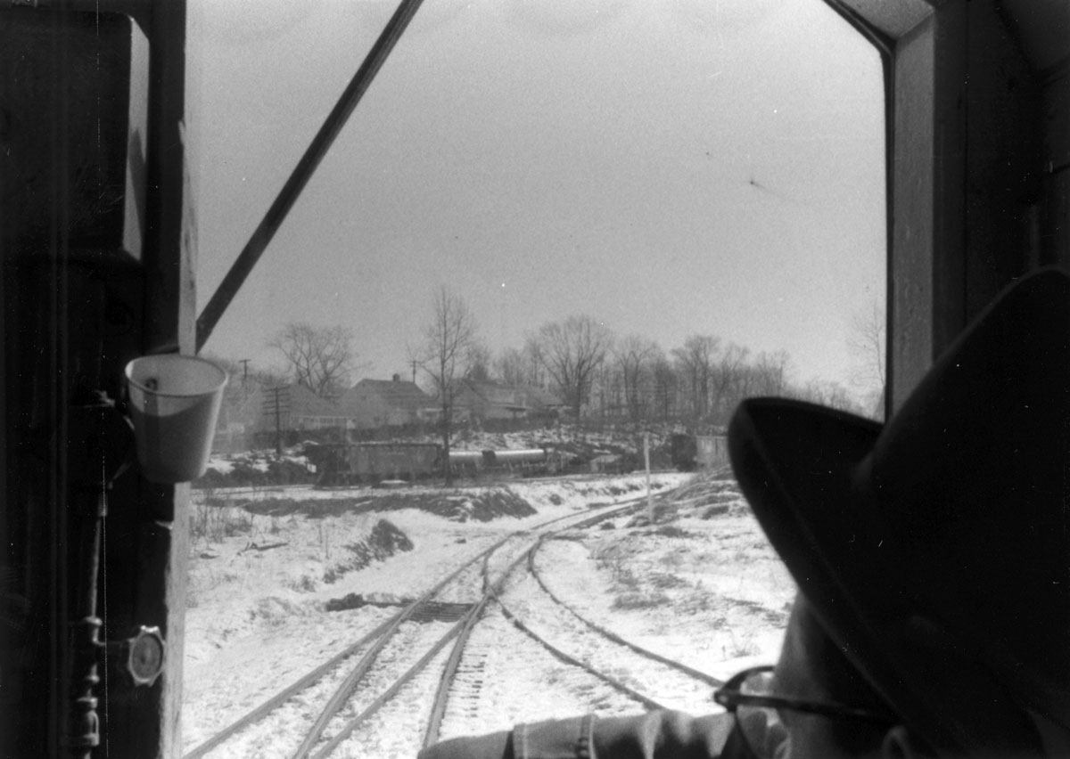
December 28, 1959 – Approaching Connecticut Ave, facing the team tracks and gantry crane. Ray Mumford photo.
If you look carefully, to the left of the tail of the train is the old gantry crane. This crane shows up in photos that I have seen from the 1920s, 30s and on into the late 50s and early 60s, possibly. The pile of stones is located near to where the crane once stood. Interestingly, the “team track” is actually to the *left* of the gantry crane in this photo, behind it. Unless the entire mechanism can rotate 180 degrees that rear track would not be serviceable by the crane. It’s a bit clearer in this photo:
Apr 2, 1956. Just West of Connecticut Ave., looking West. Photo by Ray Mumford
One can see the crane, with its tailing arm coming off the top, with the swing arm retracted to the side to allow trains to pass by. The team track is much more clearly visible to the far left. There is a suspicious pile near the team track in this photo, but you’ll notice that in the newer photo above, it’s gone. I believe the location of the stone that I found in the woods is further back, behind the crane, just out of view of these vintage photos.
So, further research is necessary to figure out this mystery. Perhaps the folks at the Cathedral could identify the stones. Or, perhaps there’s someone with a story behind how they got there. Maybe they’re just landscaping stones for a fancy building/home that a builder dumped there illegally. Or, just maybe, they were surplus stones intended to be delivered to the Cathedral site, long-forgotten and hidden from memory. All I know is that in a short amount of time; months, maybe years if we’re lucky, these will be gone. Picked up, dropped in a dump truck, and hauled away for fill, to be buried somewhere forever. I hope someone can shed some light on it before then!
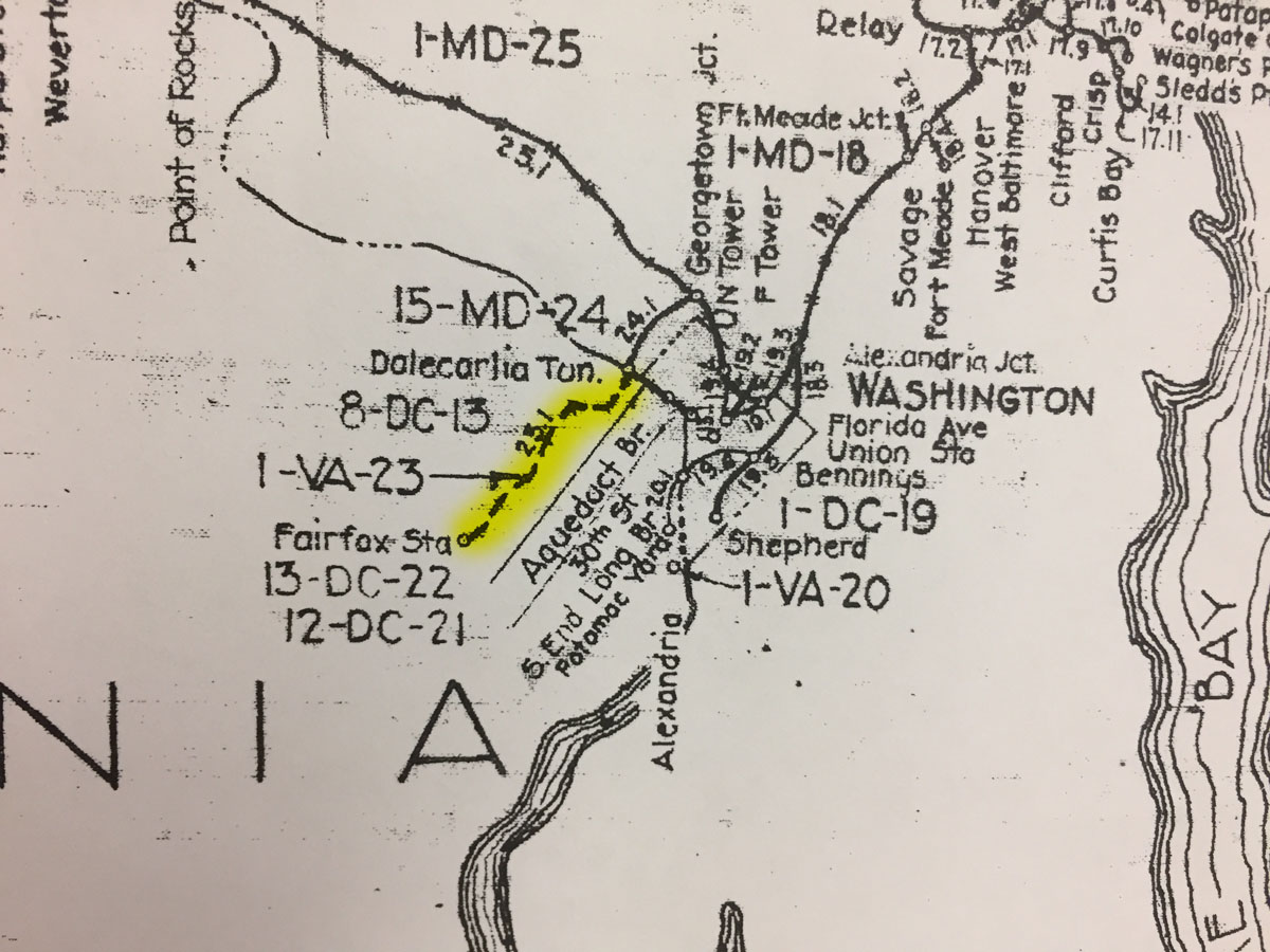
While visiting the B&ORRHS Archives building in Eldersburg, MD today I noticed an interesting depiction on the large Valuation Map “key” hanging on the wall in the collections room. This is a comprehensive view of the entire B&O RR system, with indications for major sections, distances and locations. On the map, the Georgetown Branch is indicated. However, there is a junction point at “Dalecarlia Tun.” where the Branch continues on down along the Potomac River into Georgetown. However, at the junction, there is also a dashed line that proceeds across the Potomac River and on into Virginia, terminating at “Fairfax Sta.” I have highlighted it in yellow on the photo I snapped with my phone, below.
I have researched this proposed line before, in fact I purchased a map off of eBay that showed the same proposed line and shared it on this blog. The curious thing to me is that the proposed line, which was one of the early visions/purposes for the “Georgetown Branch” was never actually built. But, it is indicated on this map, which means there are likely official Valuation maps associated with this right of way. Looking at the map, I see 8-DC-13, 1-VA-23, 13-DC-22 and 12-DC-21. I believe those are all references to maps and will have to check with the Archives to see what they have on hand. Onward…
B&O Valuation Map which shows planned VA extension
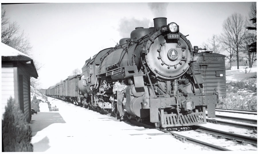
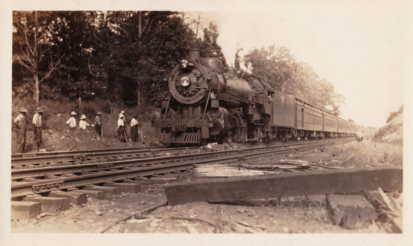
Another photo from my collection. I believe I purchased this on eBay but I’m not certain. The location is the far East end of the Georgetown Branch lead on the main line. B&O loco #4437 is on point as a crewman climbs aboard. The double-wide section shed is to the left, and still has its decorative trees in place. My best guess is that either they are dropping cars off at the team tracks or, more likely, picking them up from the yard. It appears the rest of their train is waiting on the Eastbound main of the Met. Looking at this photo just makes me feel cold! Enjoy!
It’s a frosty February 2nd in 1949 and B&O Q-4 #4437 waits for orders as a crewman climbs aboard. Location is Georgetown Junction.
I picked up this photo via eBay a couple years ago and finally got around to scanning and posting it here. The photo caption (on the back) reads: “Cap Ltd Georgetown Junction, Eastbound, after wreck.” I don’t have a date so any input would be much appreciated. My best guess is some time from the teens to the thirties. Any guesses? Note the Talbot Ave bridge in the distant background as well as the track crew hard at work repairing the fill on the far side of the rails.
The B&O Capitol Limited passes by the site of an earlier wreck as a track gang repairs the damage. Location is Georgetown Junction, MD.
It’s been too long. Over a year. I haven’t touched the layout since the summer of 2015. There, I said it. There have been many, many factors and excuses to explain this lapse, none more compelling than inertia and laziness. I’ve taken on lots of other side-projects and tasks and found many other ways to distract myself and burn time doing fun things that don’t involve working on the layout. Well, I’ve got the bug again and I’m back at it. I spent the holiday weekend cleaning out the layout room, reorganizing and getting myself mentally back up to speed with my progress on the layout.
When I had last left off I had completed much of the track in Bethesda but ran into a snag when on of my train club friends pointed out that there was a nasty S-curve in the yard entrance. I had also installed some spline roadbed at the Geo. Jct. area and that worked out quite nicely. Much of the rest of the layout was covered with “stuff”, and became staging for painting trim for our office renovation as well as other random projects. All of that stuff was cleaned up, moved out or reorganized to optimize space. I completely cleared the upper level of the layout so I could continue working on the track work I had started over a year ago. Once I got cleaned up, things really moved along nicely. I realized a few things:
I really love this project and I’m excited to see where it takes me.
I need glasses – reading glasses at least. My vision is not what it was.
I need to set some goals and stay on task.
I need to flesh out the layout design a bit more; I came across some issues that are going to prove to be challenging to overcome and will most likely require reworking some of the track plan. (oh well!)
All in all, it’s been a productive weekend and I’m moving ahead with a good head of steam. I just hope I can keep the momentum!
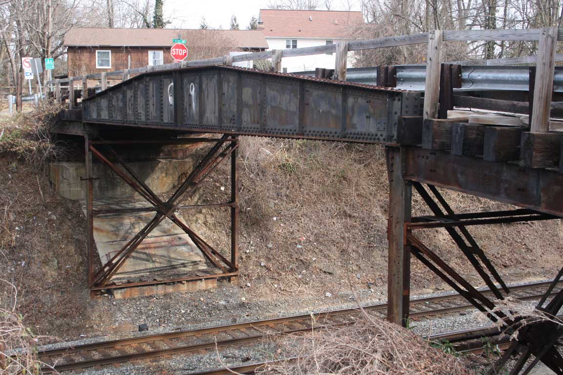
A sad, sad day indeed. A couple of weeks ago I learned about the eminent demise of the famous Talbot Ave bridge which has spanned the Metropolitan Branch and Georgetown Branch of the B&O for nearly 100 years. The bridge was built back in 1918 and is somewhat of a special legend among railfans being that the girders appear to be sourced from an old turntable, giving it the distinctive profile. This shape is recognizable in so many photos shot over the ages at the Junction. I, myself, have visited the bridge many times, shooting photos of it and from it and enjoying it as a landmark. I’m terribly sad to hear of its eminent demise and will miss seeing it at the Junction as it altered forever with the Purple Line destruction not far off. At least it will live on in my basement, as I plan on modeling it on my railroad. Here are a couple links covering its history:
On February 7, 2015 I visited the area and took many detail photos of the bridge. You can find them here on my Flickr page. (Scroll down a ways, they begin around IMG_6582)